Productive Trends
Conventional Oil and Gas production
According to Schlumberger, a worldwide leading oil and gas service company, conventional reservoirs are those reservoirs where buoyant forces keep hydrocarbons in place below a sealing caprock. Reservoir and fluid characteristics of conventional reservoirs typically permit oil or natural gas to flow readily into wellbores. The term is used to make a distinction from shale and other unconventional reservoirs, in which gas might be distributed throughout the reservoir at the basins scale, and in which buoyant forces or the influence of a water column on the location of hydrocarbons within the reservoir are not significant.
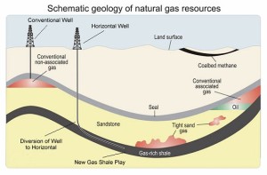 Conventional hydrocarbon reserves are obtained by drilling into a petroleum reservoir and producing the hydrocarbons using either the natural pressure of the reservoir or some type of mechanical lift or pumping action. There are a number of factors that need to be present for conventional oil and gas accumulations. First, there must be a source rock composed of organic rich matter that has been compacted by large amounts of overburder over long periods of time and subsequently cooked by the increased pressures and temperatures to generate and release hydrocarbons. Under these conditions the hydrocarbons are expelled from the source rock and migrate into the pores or tiny spaces between the rock grains once filled with water. Gas will typically migrate to the structural top of the reservoir separating from oil. Oil will fill in below the gas and “float” on water. When the pores spaces are connected by pore throats the reservoir rock is given the term permeable. Rocks with permeability and porosity allow for the migration of hydrocarbons to travel towards lesser pressure until they reach a geologic trap. A trap is a non-porous or impermeable layer of rock that will not permit the flow of hydrocarbons. There are a variety of hydrocarbon traps. The most common are structural traps and stratigraphic traps or the
  combination of both. Structural traps are associated with anticlines where hydrocarbons migrate to a structurally high position and collect. Fault traps juxtapose reservoir quality rocks against those that will restrict any flow of hydrocarbons. Stratigraphic traps are those where the reservoir rock is truncated by an overlying unconformity layer acting as a seal and or the vertical or lateral pinchout of reservoir rock into a sealing or lower permeable rock.
In summary, conventional reservoirs are reservoirs that are porous and permeable enough to allow for the economic transmission of hydrocarbons to the wellbore by natural formation pressure or conventional drilling and completion methods.
 The Austin Chalk, Buda Limestone and Georgetown Limestone are members of the Cretaceous Age Rocks which were deposited between 70 and 135 million years ago as part of an extensive Carbonate Platform and Shelf Edge Complex which wraps around the entire Ancient Gulf of Mexico. The Austin Chalk was deposited during a worldwide sea level high stand in a shallow marine environment where the seas were between 30 to 300 feet in depth.
The Austin Chalk sits directly on top of the Eagle Ford Shale which is a known excellent source rock. The up dip (as you move NW) limit of Giddings field is defined by the burial depth of the Eagleford Shale. This shale was deposited between the Austin Chalk and underlying Buda and Georgetown rocks. The Shale contains carbon-rich layers that serve as the source for oil and gas when buried to sufficient depths allowing oil and gas to migrate upward through these localized fracture networks generating large quantities of hydrocarbons to the Chalk and formations above.
The Austin Chalk is a low permeable reservoir which produces oil and gas from these series of faults and “major” fracture systems. Within the Chalk sections layers of marl are also prevalent alternating with the chalk to form a heterogeneous package. These systems are oriented parallel to the underlying Lower Cretaceous shelf edge and with very few exceptions follow regional strike with few dip-oriented fractures. The fractures within the Austin Chalk typically terminate at these sections of marl which are often one tenth the thickness of the Chalk interval. In some areas the Chalk is known to have as many as eight different productive sections. The Chalk ranges in thickness between 150 to 1,000 feet and is referred to as upper chalk, middle marl and lower chalk units. The best oil and gas production often comes from the upper or lower units as the rock has less clay content and is therefore of better reservoir quality because of its brittle nature which leads to a higher concentration of fracturing and oil and gas production. Clean chalk beds fracture when bent, whereas the marl/shale beds will not.
In Texas the systems of Austin Chalk fracturing occur within the different sections of rock and tend to run parallel to each other from the SW to the NE. Most of the fracturing occurred in response to the downwarping of the Gulf Coast Basin paired with localized regional uplifts. This parallel vertical fracturing has moderately to large spacing with few intersections between the fracture systems creating reservoir compartmentalization. It creates the perfect environment for Horizontal drilling which allows the ability to “drop” in to the productive layer and drill perpendicular to these fracture swarms thereby connecting multiple oil and gas fracture swarms together lowering risk and increasing reserves over trying to drill vertically down and intersecting one fracture system. Studies place almost half the “horizontal” wells drilled worldwide have been drilled in the Chalk. Cumulative oil and gas production from the Giddings field is well in excess of 500 million bbl of oil and 3 trillion cubic feet of gas.
Cotton Valley Group
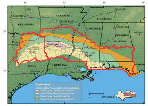
The prolific Cotton Valley Group is Upper Jurassic and Lower Cretaceous in age. Deposited some141-131million years ago, it underlies much of the northern coastal plain of the Gulf of Mexico from east Texas to Alabama. The Cotton Valley is the first major influx of clastic sediments (sandstones) into the “interior zone” of the coastal region of the Gulf of Mexico. Historically, the Cotton Valley is one of the earliest producing formations in the gulf coast region. The #1 Lanston Gas Unit “1” wildcat drilled by Mustang Drilling Ltd., in northern Louisiana in 1927 was the discovery well for the Cotton Valley. In 1937, the Cotton Valley Blanket Sandstone reservoir was being commercially drilled in northern Louisiana. By the early 60’s, the blanket sandstone production had matured and production waned. New technologies applied to the play, such as massive hydrologic fracing, rejuvenated the Cotton Valley play during the 70’s. Gas production from the low porosity and low permeability portion of the Cotton Valley Massive reservoir was being commercially exploited. Fracing is a mechanical method applied to the reservoir that helps to “stimulate” production greatly increasing initial flow rates. It also has helped to maintain flow rates in many reservoirs. When fracing a Cotton Valley well it is not uncommon to see production from a 500 (million cubic ft per day) MCF/D increase to 2,500 MCF/D after fracing stimulation. Most production ranges from depths of 7,000 to 10,000ft, however, the Cotton Valley reaches production depths of 20,000ft with much of what lies under 10,000ft unexplored.
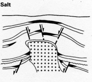 Geologic History: As the early Gulf of Mexico opened up due to continental movement during the late Triassic period approximately 210 million years ago, a regional depocenter (low area or basin) was formed. Three of these major basins were formed, the East Texas Salt Basin, North Louisiana Salt Basin, and the Mississippi Salt Basin. Sediments rushed in from the north to fill the low area. The Louann Salt became mobile as a result of massive sediment loading and being under high pressure. This caused upward salt movement creating structural highs and several different types of traps were formed favorable for the accumulation of oil and gas in the Cotton Valley Group. Today, the many fields that produce from Cotton Valley Group in east Texas, Louisiana, and Mississippi are from those types of traps associated with Louann Salt structures. In addition, it is common to find oil and gas trapped in other types of traps such as where blanket sandstones pinch out across anticlines or structural noses or stratigraphic pinch outs.
The source for hydrocarbons in the Cotton Valley Group is thought to be the Bossier Shale and Smackover formations. Ro values, vitrinite reflectance a way to determine thermal maturation, were measured using the present day geothermal gradient of 2.1°F/100ft for the Bossier Shale and Smackover formation. Estimated values of 1.8 to 3.1 percent and 2.2 to 4.0 percent Ro suggest that these source rocks have reached a thermal maturity in which dry gas was generated. The Bossier Shale is a dark-gray, calcareous, fossiliferous, shale ranging in thickness from 250 to 2,000ft. Hydrocarbons sourced from the Bossier and Smackover formations and trapped in the Cotton Valley Group make the Cotton Valley Group one of the premier oil and gas targets in America.
Reservoir: The terrigenous clastic dominated Cotton Valley Group was deposited conformably on top of the Gilmer formation. The Cotton Valley varies regionally but is interpreted broadly to be two main deltas one in east Texas and the other in Mississippi. The Cotton Valley strata form a sedimentary wedge as the sedimentary units thicken towards the Gulf of Mexico. In east Texas the Cotton Valley Sandstone consists of braided-stream, fan delta, and wave dominated deltaic sandstones. In northern Louisiana the stratigraphically equivalent sandstone depositional environments were stacked barrier-island, offshore-bar, strandplain, and fluvial deltaic units locally named the Terryville Massive sandstone. The Terryville sandstones further south are deposited as high-energy barrier islands allowing precipitation of quartz cement. The quartz cement damaged the reservoir resulting in 6-10% porosity and .042 millidarcies in east Texas and .015 millidarcies in northern Louisiana sourced by USGS the authors are T.S. Dyman and S.M. Condon published in 2006. Terryville massive sandstones require massive hydraulic fracturing because of their poor reservoir properties. The updip Terryville blanket sandstones can be separated into several tongues of sandstones that pinch out at the Hico Shale. These blanket sandstones have been reworked by transgression events and are more mature and better sorted than the main body Terryville sandstone. They are noted to be superior reservoirs that have high permeability averaging 110 millidarcies and porosities averaging of 15%. These superior reservoir qualities developed because clays were deposited which inhibit quartz overgrowths, and secondary porosity was generated through dissolution of calcite cement. The sandstones in the Cotton Valley Group are divided into two trends, a high permeability blanket sandstone and a downdip, low permeability massive sandstone. Across the hydrocarbon-productive trend in the Cotton Valley Group sandstone thicknesses are about 1,000-1,400ft.
Oil and gas potential: Today there are estimated undiscovered reserves in the Cotton Valley Group of 605 billion cubic ft of gas (BCF), 29.81 million barrels of oil (MMBO), and 19 million barrels of natural gas liquids (MMBNGL) making the Cotton Valley Group one off the premiere oil and gas exploration targets. We look forward to having you explore our prospect with us.
Edwards Limestone
 The Edwards Limestone Formation is a narrow belt of tight limestone that extends from Webb County, Texas, through LaSalle, McMullen and Live Oak counties and continues into East Texas. The early wells in this formation produced gas or gas condensate. There were also several pools that produced oil but they typically had a high gas/oil ratio. Current reservoir depths range from 10,000 feet to greater than 14,000 feet. The Edwards reservoirs tend to have a low permeability and porosity. Due to the introduction of horizontal drilling in the 1990s, activity in the area has rebounded.
Miocene Sands
Geologic formations identified as upper, middle and lower Miocene sands extend from the Gulf Coast northward into Texas and Louisiana
Smackover
The Jurassic Smackover was initially discovered when a test was drilled in the shallow Smackover Field in Union County, Arkansas in 1937. After this discovery, the Smackover became one of the most desirable Jurassic objectives in the Gulf Coast area.
Wilcox Sands
The Wilcox Group is Paleocene and Eocene in age ~59 – 52 mya and consist of the lower Wilcox and the upper Wilcox as the major oil and gas producing intervals in the formation. The Wilcox trend stretches from west Texas near the Mexico border to southern Louisiana and Mississippi. The Wilcox formation is a thick sequence of non-marine sands, silty sands, cross-bedded layers of shale, clay and gravels with some thick deposits of lignite. The thickness of the Wilcox ranges from a featheredge to as much as 2,000 ft. Wilcox production is from shallow depths of 2,500 ft to depths greater than 25,000 ft. The depositional facies represents fluvial, deltaic and lagoonal sediments. In the outcrop and shallow subsurface, the Wilcox was deposited predominantly in fluvial environments. Downdip, the main Wilcox productive reservoirs were deposited by large deltas and associated barrier-bar and strandplain systems. The Wilcox sandstone is the first major progradational sequence of terrigenous clastic sediments that is separated into upper and lower progradational phases by a retrogradational phase in the middle of the sequence. The Wilcox group exploration began in the late 1930’s. There are 3 major Wilcox plays WX-1 Wilcox Sandstone, Houston Embayment, WX-2 Wilcox Lobo Trend, WX-4 Wilcox Sandstone Rio Grande Embayment. Together these three plays have produced from nearly 400 different fields. The Rio Grande Embayment is the largest and has produced 15,555,179 MMcf up until 1996 according to the Bureau of Economic Geology. The Wilcox formation is a leader in natural gas production in Texas. Because of prolific hydrocarbon production from numerous reservoirs in Texas, Louisiana, and Mississippi the Wilcox formation has been a major target for shallow and deep hydrocarbons, but still has large reserves yet to be discovered. The extensive Wilcox growth fault zone of syndepositional normal faults, with associated dip reversals and rollover anticlines, that developed along the unstable Wilcox shelf margin, is the main structural feature responsible for the formation of major natural gas trapping mechanisms.
(WX-1 Houston Embayment) The Houston Embayment was discovered just before 1960 and has seen in increase in the number of fields since then to 89 fields. The large natural gas play is situated in the middle to upper Texas gulf Coast Basin. The average completion depth is about 10,650 ft. In 1996 the ultimate recovery for this play was 7,632,128 MMCf according to the Bureau of Economic Geology. The structural style of the Houston Embayment Wilcox trend produces from the prograding sands over the shelf edge, creating a zone of listric normal growth faults. Almost all fields in the play lie in the Wilcox growth fault zone, which extends downdip from the Cretaceous Stuart City shelf margin. The major fields are named Sheridan, Provident City, katy, Columbus, and Chesterville N. Traps are formed primarily in anticlines and faulted anticlines on the downthrown side of growth faults. Distinctive patterns of sandstone distribution and facies can be found in reservoirs in the Houston Embayment since the Lower Wilcox was deposited by lobate, fluvial dominated deltas. The reservoir facies are distributary-channel, channel-mouth bar sandstone, and delta front sandstones downdip. The upper Wilcox was deposited primarily by more wave-dominated deltas, where most of the sand is reworked and is deposited along the delta-flank shoreface. Possible source facies of this play come from prodeltaic mudstone interbedded with the reservoir sandstone.
(WX-2 Lobo Trend) The Lobo Trend as of exploration maturity is relatively new, it is an immature play discovered in 1973 in Webb and Zapata counties. Since the discovery the Wilcox Lobo Trend has shown a rapid increases in natural gas production and proven reserves. This play has produced 6.4 Tcf gas equivalent from more than 4,200 completions with an estimated 75 % success ratio. The Lobo trend produces from about 90 fields with the average completion depth of 9,600 ft. The major fields are Vaquillas Ranch, Laredo, JC Martin, La Perla Ranch, and Benavides. In 1996 an ultimate recovery was estimated to be 8,485,236 MMcf. The Lower Wilcox is defined generally progradational stratigraphic sequence between the Midway Group and the middle Wilcox shale unit above. A series of lowermost Wilcox deltas prograded across an unstable shelf margin composed of unconsolidated mud in the Midway Group. Gravity sliding and intense faulting of the entire lower Wilcox section into numerous fault blocks over the Midway muds occurred soon after lower Wilcox Lobo sands were deposited. This structural activity was followed by a period of erosion that reworked the Wilcox sands in many of the higher fault blocks. After faulting and erosion the Lobo sands were covered by the thick middle Wilcox shale, which provided as a master seal or a major trapping mechanism. The Lower Wilcox Lobo sandstones are the major low permeability natural gas producers of the Texas Gulf Coast. Porosity and permeability ranges from 12 – 25 % and .0003 – .5 md respectively, are common for producing sandstones. Almost all Lobo sandstones must be stimulated by fracture techniques. Typical fracture stimulation treatments averaged 101,800 gal of gel and 207,000 lb of proppant. These reservoirs require advanced recovery techniques in order to fully recover Wilcox Lobo’s natural gas.
(WX-4 Rio Grande Embayment) The Wilcox Sandstone Rio Grande Embayment trend is the largest play for the Wilcox Group produces from 206 fields. Production in the last 20 years has shifted from shallowest upper Wilcox to the deepest Wilcox sequence. It is characterized by growth faults and deltaic sandstone reservoirs. Many of the deeper reservoirs are geopressured and typically have pressure-solution drives, but the most prolific reservoirs are normally pressured and have solution-gas and water drives. Many of the fields that produce from the middle Wilcox are designated as tight gas sandstones. The average completion depth is nearly 10,000 ft. Until 1996 the ultimate recovery for this trend was estimated to be 15,555,179 MMcf. The major fields are Double A Wells, Brookeland, Madisonville and Lola. The structural style for this play is closely spaced growth faults and rollover anticlines. The deep Wilcox natural gas reservoirs are highly faulted because of deposition along an unstable shelf margin. Closely spaced growth faults having thousands of feet of cumulative displacement characterize the deep Wilcox Formation. Traps are formed primarily in faulted rollover anticlines on the downthrown sides of growth faults. It is important to position wells that penetrate fault blocks that were trapped at the time of sand deposition and not later. The majority of fields produce from highside closures against down-to-the-coast faults. Abundant shelf and slope mudstones in the deep Wilcox Formation form both the source and seal for natural gas reservoirs in the Wilcox Rio Grande Embayment. Upper Wilcox reservoir facies are diverse and include channel-fill and crevasse splay sandstones that are interbedded with delta-plain mudstone. Delta abandonment was followed by transgressive deposition of marine mudstone over Wilcox sandstone facies, therefore; Wilcox deltaic natural gas reservoirs in the Texas Gulf Coast basin are typically stratigraphically complex and display variable lateral continuities.
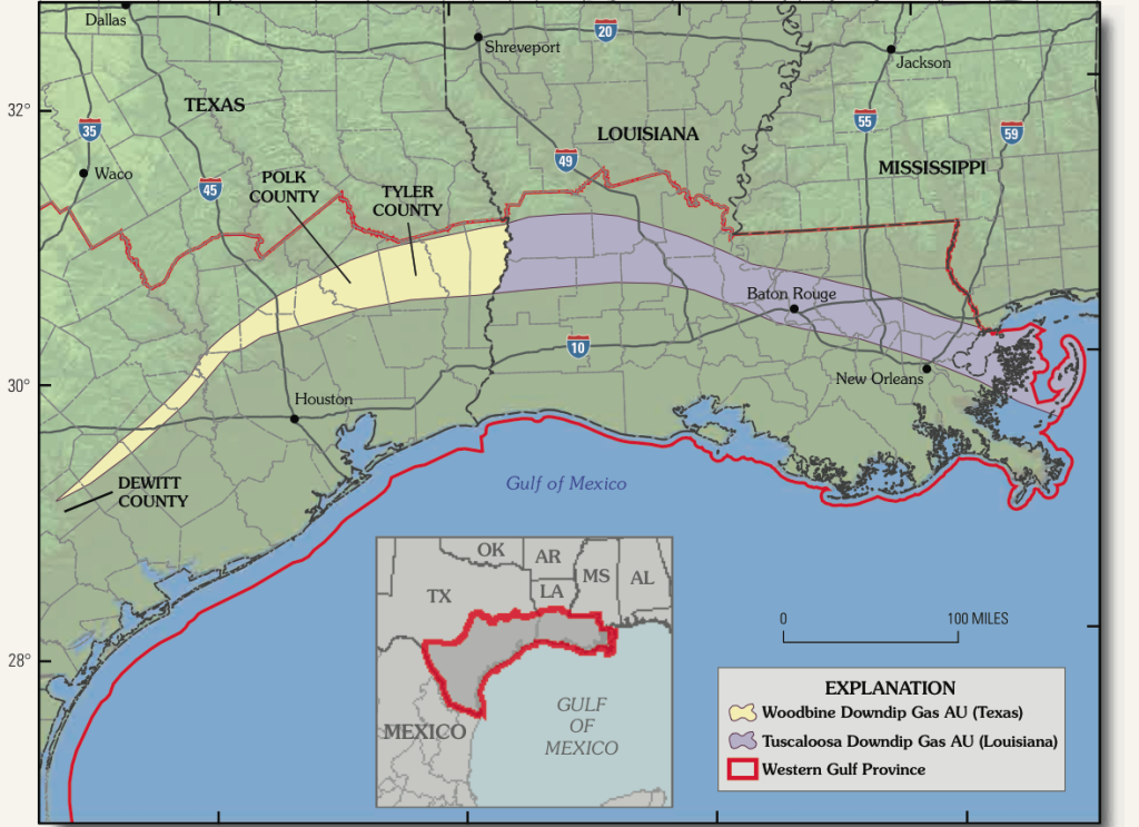
Woodbine and Tuscaloosa Trend
The Woodbine formation and the Tuscaloosa formation are laterally stratigraphically time equivalent units deposited during the late Cretaceous period approximately 100 to 90 million years ago. Regionally, the Woodbine is located in Texas and the Tuscaloosa is located in in Louisiana and Mississippi. The Woodbine sand is currently one of the largest single oil pools discovered in the world. The Woodbine is 44.32 miles by 4.94 miles and covers approximately 140,000 acres. The Woodbine has an estimated ultimate recoverable reserve of 7,700,000,000 bbl. There are over 80 individual pools that are currently producing from the Woodbine.
The first discovery well of the Woodbine was drilled in Mexia, TX in October of 1920. The south central Louisiana Tuscaloosa gas play was discovered by Chevron in 1963. In east Texas the Woodbine sand has produced 5.42 billion barrels of oil and recent evaluation concludes there is still deeper Woodbine pay of 410 million barrels of oil remaining according to the Bureau of Economic Geology. The Woodbine and Tuscaloosa formations both consist of interbedded conglomerates, sandstones, and shales. In Louisiana, the clastic sediments of the lower Tuscaloosa were deposited below a marine shale unit that correlates with marine shales of the Eagle Ford Group that overlies the Woodbine formation in Texas. The major production of natural gas in the Woodbine and Tuscaloosa formations comes from two areas, one near Baton Rouge, La. and the other in Polk and Tyler Counties, Texas, which lies north of the Angelina-Caldwell flexure and the Edwards reef trend. The late Cretaceous continental shelf is marked by the Angelina-Caldwell flexure and the Edwards reef trend. Depositional environments of Woodbine and Tuscaloosa sands and subsea formation tops are greatly affected by their location from the continental flexure zone. The shallow Woodbine represents deposition north of the shelf edge and the deep Woodbine represents the deposition south of the carbonate edge. Production from the Woodbine ranges from depths of between 3,000’ to 6,000’ north of the paleo shelf edge. Recent discoveries of Woodbine gas have nowextended the area of exploration south of the Angelina-Caldwell arch where the Woodbine is found much deeper. The Woodbine in this area is encountered at depths of 10,000’ to greater than 15,000’.
 Sediment deposition was greatly influenced by the Laramide orogeny and the Ouachita Mountains sourcing from the north northwest and salt structures rising from below. Both orogonies originated from a compressional event that created anticlines and down warping in the continental platform which created depocenters where clastic sediments would accumulate in the trend. Older strata from below, the Louann Salt penetrated the overlying lower Cretaceous carbonate section that is subjacent to Woodbine and Tuscaloosa, which created a trapping mechanism for hydrocarbons. Areas that lie in-between the salt ridges had greater sediment deposition by means of low topography. Channels that were able to prograde would dump the denser sediment onto weaker distal muds. When a channel progrades too far, the ground below is too weak and begins to slide along a listric growth fault. The fault is continuously sliding as the sediments are being deposited. Strata in a syndepositional fault thickens from the bottom to the top, sometime when there is a complex of growth faults rollover anticlines can form by compression of the beds within each individual fault. Rollover anticlines are common within growth faults, and both of these processes create structures that act as a good trap for hydrocarbons. A different style of trapping hydrocarbons are where salt domes and salt escarpments create a positive uplift in between horizontal beds making those beds impermeable to the salt. A faulting pattern will be generated from these positive high structures making fault blocks near the salt dome a interesting area for hydrocarbon accumulation.
The source of hydrocarbons in the Woodbine and Tuscaloosa formations are theorganic rich shale’s from within these formations. In the upper section of the Woodbine there are algal lignite laminations that potentially have large volumes of reserves yet to be discovered along strike producing areas, and also likely down dip areas are considered to be unexplored. The USGS assessed undiscovered conventional gas resources in the Woodbine and Tuscaloosa combined to be20.8 (trillion cubic ft gas) TCFG of non-associated gas “dry gas” and 0.6 (billion barrels of natural gas liquids) BBNGL. The Tuscaloosa gas play represents 16.2 TCFG and the Woodbine contains 22% of the combined undiscovered gas play.
Woodbine and Tuscaloosa sediments weathered from the Ouachita Mountains in south Oklahoma and Arkansas and deposited as nearshore and shallow marine depositional systems consisting of fluvial, deltaic, and shelf deposits. The Woodbine is divided into two members a lower Dexter member and an upper Lewisville Member. The Dexter member was deposited in a fluvial system consisting of tributary facies and meandering facies that developed northeast of a line from Dallas to Tyler. The member can be separated into two units by upper variegated clay layers and lower red ferruginous sands. The Lewisville Member that overlies the Dexter Member is a marine environment made up of marine muds and shales deposited along the coastline, marginal to active delta systems. The member is highly fossiliferous, containing abundant shore fauna representing shelf facies. The sand facies occurs as lenticular, cross-bedded ferruginous sands with lignite beds between mud and shale beds. The Woodbine has three principle delta systems that consist of, 1) prodelta 2) delta front, and 3) delta plain. The prodelta is the deep-water portion of the deltaic system where muddy facies along with intermittent fine sands are deposited. Prodelta deposits occur at the base of sections usually about 3-5 ft of mudstone, overlain by about 10ft of interbedded silts and wavy laminated sands. The sand coarsens upwards as the prodelta facies grades into the delta front. The delta front has the most abundant sedimentation and progrades out over the prodelta muds. These sands are more influenced by fluvial sedimentation and consist mainly of coarsening upwards sands and laminated silts and muds. The delta plain is the emergent portion of the deltaic system where sedimentation occurs in channels, levees, tidal flats, and marshes. The majority of the sediments are sand. Less amounts of silt, clay, organic matter, and coal or peat are deposited as well. By the end the Woodbine deposition, but before the transgression event by the Eagle Ford seas, the emergence of the Sabine Uplift resulted in reworking of the sediments and by longshore currents redistributed the Woodbine sediments to the south and southwest into a large peninsula that partially closed off the mouth of the East Texas Basin called the Harris Delta.
The beginning of the lower Tuscaloosa was a period of major sea level regression. The Tuscaloosa depositional environments graded upwards as a period of sea transgression followed in the latter part of the Cretaceous from alluvial plains through deltaic deposition to marine deposits. The basal unit has an upper section called the Stringer Member with alternating shales and sands with a lower section called the Massive Sand Member that is dominated by sand. The deposition is interpreted to be an upward gradation from fluvial and deltaic sedimentation to shelf deposition (alternating shales and sands). The well-sorted, clean sand in the Stringer Member is a candidate for exploration because of its good porosity and permeability showing a higher SP and resistivity curves. The Lower Tuscaloosa member is ~375’ with a strike of northwest-southeast and a dip to the southwest in south Mississippi. As the sea continued to transgress during the Middle Tuscaloosa the fluvial-deltaic sediments of the lower Tuscaloosa were covered by marine shales of the middle Tuscaloosa. Much of the northern Gulf of Mexico was covered by this marine transgression, which consists of dark shales with minor amounts of interbedded sand and silts. The middle Tuscaloosa unit is about 460’ section of shale as the primary rock type. The upper Tuscaloosa terrigenous clastics continued to be deposited as the sea level transgressed and the shoreline retreated to the north and north east. It is mostly dark shale, firm to moderately hard with minor interbedded sands and siltstones. The sandstones have sparingly glauconite, which represents a marine depositional environment.
Deep Woodbine and Tuscaloosa Trend
Unconventional oil and gas production
Declining oil production and the rise in the price in oil has led to the emergence of many unconventional oil and gas plays. Unconventional, in the sense these reservoir rocks are usually much tighter than conventional oil and gas plays. It takes special drilling and completion technologies to allow for the extraction of hydrocarbons from these tight reservoirs. Geologists and engineers have always known there were hydrocarbons trapped within these reservoirs, but until recently they have not been economically producible. Advances in drilling and completion technologies have allowed operators to economically explore for and produce these formerly uneconomic reserves.
 The reservoirs are commonly found in geological formations that have very low permeability and usually require some form of hydraulic fracturing or horizontal drilling to produce the oil and gas. Historically, early shale plays that were drilled with vertical wells had a recovery rate of about 2% of the original gas in place. Today, those same shales typically have recovery rates within a range of 15-35% utilizing new technologies. With large reservoirs, high gas prices, and technological advances, unconventional drilling has contributed a dramatic amount of reserves in the past decade. Today, the United States is on the verge of being the largest hydrocarbon producer in the world largely due to unconventional plays. There are many different types of shale plays. Shale gas, shale oil, coal bed methane, tight gas sands, and methane hydrates (not yet technically recoverable) are some examples. Tight gas reservoirs are defined as production from low permeability reservoirs. These are the most predominant forms of unconventional gas production. Shale gas is natural gas produced directly from the sedimentary shale layers buried thousands of feet below the surface. It is common for the shale strata to be the source rock for many conventional hydrocarbon plays. The organic rich shales are subjected to extreme temperatures and pressures to generate the hydrocarbons. Over geologic time those hydrocarbons migrate out of the shales and are sometimes trapped in reservoir rocks. Even though the shales have been the source for hydrocarbons in other reservoirs, in many cases there are still much greater volumes of hydrocarbons left over within the source shale rock. Shale oil is similar in nature to the shale gas plays, however; hydrocarbons are generated in liquid form. Coal bed methane is generated during the transformation of organic plant material into coal. The gas is usually trapped by tiny fractures called cleats and held in place by pressure. Many coal bed methane plays are shallower than 2,000ft below the surface. Coal bed gasses are extracted via wells drilled directly into the coal seams. Operators will usually have to produce large quantities of water, called dewatering, to allow the gas to start flowing out of the tiny fractures and into the wellbore.
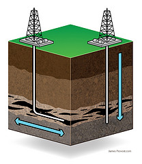
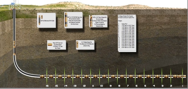
With the combined technologies of horizontal drilling and hydraulic fracturing operators have been able to expose their wellbores to much greater volumes of the reservoirs. This has allowed the companies to drain much larger areas of the reservoir then previously they were able to with vertical wells. One horizontal well can now be drilled several thousands of feet laterally in a reservoir targeting multiple fracture zones or allowing multi stage fracs to be applied to the well. In many cases applying these new technologies to unconventional reservoirs have turned uneconomic plays into economically violable ventures.
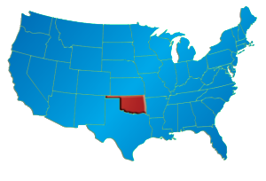
Oklahoma’s SCOOP and STACK oil plays … Some of the best rock seen anywhere!
Traveling through Oklahoma’s stratigraphy, one can stumble over as many as 7,500 formations. “Most have names; in some cases, several,” the Oklahoma Geological Survey explains in an oil and gas FAQ page. The abundance of nomenclature is the result of many factors, the OGS adds, including simply that, at times, “geologists may disagree.”
The state also hosts more than 3,000 field designations. To simplify, strat-trippers can cheat down to the 300 formations that have had 10 or more well completions. Among them is the Woodford Shale, which Newfield Exploration Co. proved commercial from fracked horizontals beginning in 2005 where the pay is gassy in the Arkoma Basin of southeastern Oklahoma. Read the full article at here at oilandgasinvestors.com